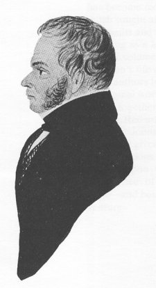
Isaac Johnson - surveyor and artist
Isaac Johnson was not born in Woodbridge but he made the town his home for 50 of his 81 years and carried on his land-surveying business here.
Isaac Johnson's grandfather was a farmer in Debach. His father was born in 1722 and twenty years later he married Mary Nichols of Sutton and the couple went to live at Pettistree. This is where Isaac and most of his eight siblings were born. Their father was a surveyor and, sometime after 1760, he and his family moved to Alderton where he became bailiff of the manor of Hollesley with Sutton. Isaac took over this post in 1778 but, by 1783, he had moved to Woodbridge where he set up his practice as a surveyor.
Isaac Johnson
Little is known about either Isaac Johnson's early years in Woodbridge or of his wife Elizabeth Maxwell whose father was a worsted weaver in Norwich. The couple, who were both nonconformists, were married in Norwich in 1786. They had twelve children and six were baptised in the Quay Chapel. Only five of the children lived to maturity. In 1798 the family moved into a house on the lower Thoroughfare, now called Cumberland Street. This painting shows the family in 1803.
Johnson produced detailed maps of many of the estates, large and small, in the eastern half of Suffolk, as well as many in neighbouring Norfolk and Essex.
Johnson also possessed a considerable artistic talent. Wherever he travelled to make surveys he made time for quick sketches of churches, houses and architectural antiquities. These he would work up later into finished drawings, or watercolours.
John Nichols, a publisher, met Johnson in about 1785 and commissioned drawings of antiquities in local churches which were then engraved for publication, some appearing in Nichols' Gentleman's Magazine. In 1788 Johnson was working with Robert Loder, the printer and publisher of Woodbridge, and produced engravings for sale and for use in books.
Johnson produced a volume of illustrations of 514 Suffolk Churches, complete with map and alphabetical index, and also various customised volumes of Architectural and Monumental Remains. For this the client chose from a selection of churches, monastic ruins, castles etc
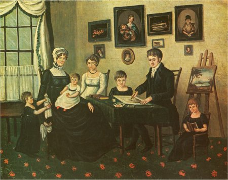
The Johnson family in 1803
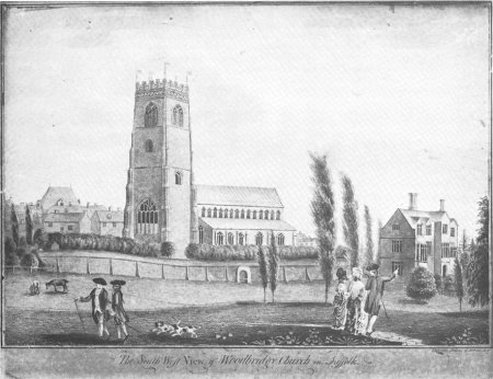
Johnson’s drawing of the south view of St Mary's Church
and the Abbey at Woodbridge .
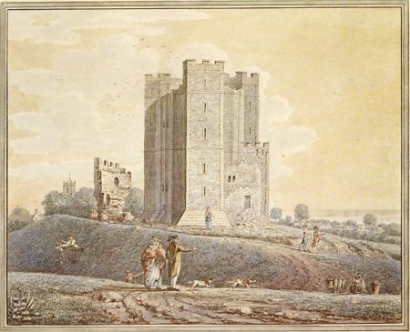
Orford Castle.
Johnson had a passion for trees, and he had it in mind to produce a volume of remarkable trees in Norfolk and Suffolk. Several of his original paintings for this book exist but the work was never completed. One of the these paintings. is shown on the left.
Many of Isaac Johnson’s estate maps survive but perhaps his greatest legacy to Woodbridge are his maps of the town. The earliest is a small map of the town in 1827. This map is on sale in Woodbridge Museum.
In 1830 he produced a detailed map delineating the properties belonging to the manor of Hasketon and those of the Manor of Woodbridge late Priory. This large map which, at the Ipswich Record Office, is so large that it is hard to use, is a gold mine.
Isaac Johnson's painting of an oak tree on
Worlingham Common. This oak, adjacent
to the road crossing the common, was
formerly the residence of a cobbler.

Johnson’s wife died in 1813 and four years later he married Mary Fisher of Woodbridge. He was then aged 63 and she was 28. The couple eventually moved into 7, Market Hill, the house next to Woodbridge Museum, and it is there that Isaac Johnson died in 1835. He is buried nearby in St Mary's churchyard which is to the rear of the house.
Within days his widow transferred all her husband’s business to Benjamin Moulton although there is no evidence of either a previous connection between the two men or of any indication that Johnson had indicated that he would like this transfer to take place.
Moulton received Johnson’s vast accumulation of survey material and account books and set about using the material to produce the 1838 tithe map of Woodbridge. This is the earliest detailed map of the town. It, and the accompanying apportionment, have been much used by those interested in the town ever since.
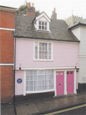
7, Market Hill, Isaac Johnson's last home
In 1818 William Cubitt, the Ipswich civil engineer, commissioned Isaac Johnson to survey a road which would link (i) the landing area on the Sutton side of the ferry from the Tide Mill at Woodbridge and (ii) the road (now the B1083) running from Wilford Bridge to Sutton. The proposed road was 3 km long and was perfectly straight. It would have intersected with the road to Sutton at the point where there is now a car park and picnic place for Sutton Heaths. The map does not reproduce well so the route is best shown here by superimposing the route of the road on a extract of the 2006 OS map.
Isaac Johnson's produced the map showing the route of the proposed road in September 1818 and William Cubit added his signature to the map when he deposited it with Clerk to the Suffolk Quarter Sessions on the 29th September 1818. The map does not reproduce well so the route is best shown here by superimposing the route of the road on a extract of the 2006 OS map.
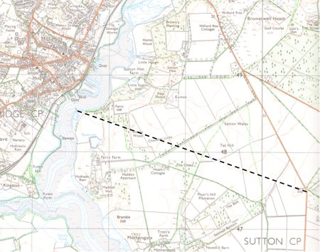
The dotted line shows the proposed route of the road linking
the ferry to the he road running from Wilford Bridge to Sutton.
At high tide, the ferry from Woodridge ran from a causeway running between Ferry Quay and Tide Mill Quay. When the the water level fell people had to reach the ferry by walking along a "hard". The route of the hard is shown by the red line superimposed upon this extract of the 1881 OS map. At low tide the channel that the ferry had to cross was only about 60 ft wide.
When a copy of Isaac Johnson's map appeared in book by John Blatchly in 2014 it immediately became clear that there was a connection between the map and and a drawing which, for many years, had been in store room at Woodbridge Museum. The drawing is an elevation and plan for a swing bridge over the River Deben at Woodbridge. It was signed William Cubitt and dated 23 September 1818. The bridge is 53m long but only the central 10m section would have swung open to allow vessels to pass. Presumably the bridge would been placed over the channel used by ferry at low water and that it would have been reached by creating a line of pontoons along the ferry hard leading to the low water channel.
Photographs of the plan and elevation of the bridge are shown below.
There is no evidence that the idea of building of the road and the bridge was taken any further.
After his time in Suffolk Cubitt moved back to Norfolk and was engaged canal
engineering projects. In 1825 he moved to London and became an expert
witness at parliamentary enquires and four years later he was elected a
Fellow of the Royal Society. He was chief engineer on the South Eastern
railway to Dover and Folkestone and crossed to France to work on the line
between Boulogne and Amiens. Because of his major involvement in
the Crystal Palace for the Great Exhibition of 1861 was knighted at Windsor
by Queen Victoria.
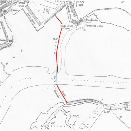
Map showing the route of the low water ferry and of the hard which provided access to the ferry at all stages of the tide.
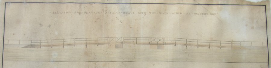
Elevation view of a swing bridge over the River Deben at Woodbridge.
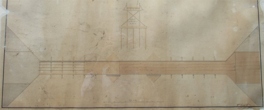
Plan view of a swing bridge over the River Deben at Woodbridge.
Isaac Johnson of Woodbridge 1754-1835, John Blatchly and Peter Eden, published by Suffolk Record Office.
Isaac Johnson of Woodbridge Georgian Surveyor and Artist, John Blatchly, published in association with the Suffolk Record Office.
Last edited 21 Aug 23