Old, and Some New, Photographs of Woodbridge & Melton
By 1859 only a small amount of land within the triangle between Quayside, Station Road, Kinston Rd, Jetty Lane and the railway had been built on. The map on the right show the extent of the building by 1859 and the changes which had occurred by 1960.
On the 22nd Nov 1817, the Suffolk Chronicle carried the report of a vestry meeting at which the 'necessity of lighting the town was urged'. William Lockwood describes Woodbridge prior to gas lighting thus - 'At night the streets would be unlit. The gloom would only be unbroken by the flickering oil lamps outside some Hotels and large houses.'
Sometime later the Woodbridge gas works was commissioned but it is not clear as to when the work was completed. All that is known for certain is that, by 1838, the Woodbridge gas works was near the end of Quayside. The gas works was enlarged in 1872, presumably to satisfy the increased domestic demand. At about the same time the Trade Directories recorded the first gas fitter in the town. He was Alfred Gale who previously only appeared in the directories as an ironmonger. Gale was also agent and collector for the shareholders who owned the gas works.
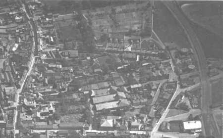
The Woodbridge Gas Light and Coke Company was producing gas on Quayside until at least 1929 when the area supplied by the Ipswich Gas Light Company was extended to encompass Woodridge. The gas was then piped from Ipswich but two gas holders were retained to regulate the supply. One was removed in about 1960 and the other remained standing until the Thoroughfare and Cumberland Street bypass was built in 1976.
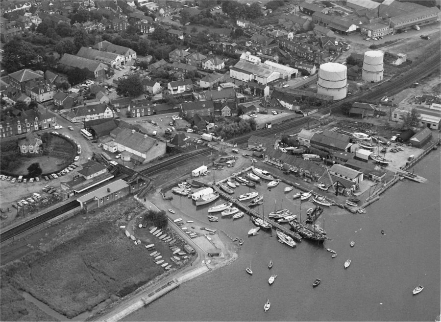
The two gas holders are on the left of this aerial
photograph taken in about 1935.
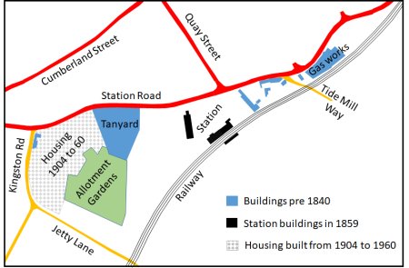
Buildings in the triangle railway and
Quayside and Station Road by 1859
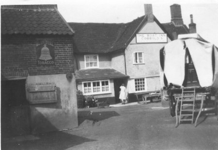
Between Tide Mill Way and the station there was the Boat Inn, a cluster of houses and a line of warehouses which had all been built before 1840. In 1957 the Boat Inn closed and it became a residence. Since then the there have been no major changes to these buildings.
The Rear of the Boat Inn in 1935
By far the largest cluster of buildings by 1840 was a large tanning office and some cottages, a complex which became known as the Tanyard. The clay lands of East Suffolk had become an important region for leather production some leather is likely to have been processed in Woodbridge.
The Tanyard was eventually taken over by Skinner’s Motor Body Repair Shop and Kay’s Engineering.
The electricity supply for Woodbridge was first supplied from a building at the corner of the Tanyard. Lambert's Almanac Retrospective for 1908 stated that the 'question of electric lighting has been repeatedly discussed (by the Urban Council), but whether electricity will eventually oust gas light from Woodbridge remains yet to be seen.' Thus it would appear that the people of Woodbridge were undecided about the relative merits of gas and electricity.
In August 1913 the Woodbridge and District Light Company switched on lights in the town. The power station had a direct current generator driven by a gas engine which used gas from the gas works on Quayside. The offices of the Woodbridge and District Electric Light Co Ltd. were at 11b Church Street.
The Tanyard power station became redundant in 1937, when the supply was switched to AC generator by the East Suffolk Electricity Distribution Company who had built a power station at Cliff Quay, Ipswich. All that remained of the generating site in Woodbridge is the distribution transformer adjacent to what is now Tanyard Court. The switch over from AC to DC was uneventful - much to the dismay of the local children who were expecting a display of sparks. The National grid introduced in the 1930’s and from then on the local power stations were gradually phased out.
On the 1881 Ordnance Survey map the road that we now call The Avenue is shown as Jetty Lane and there is a rope walk running along the town side of this lane. Writing in the 1950s, Arnott records that rope was made there within living memory.
As early as 1338 large quantities of Woodbridge rope, made from locally grown hemp, been bought for the fleet of Edwards III which was assembling at the mouth of the river. From the 16th to the mid 18th century Woodbridge rope was used by the navy. The production of all rope for the navy was subsequently centred on Bridgeport and the rope produced in Woodbridge was only used for merchant vessels. The main ropewalk was between The Thoroughfare and the Tide Mill but after it closed in second half of the 19th century smaller rope walks were established. One of these adjacent to Brook Lane and the other was alongside Jetty Lane.
From 1904 to 1960 houses were built along part of Station Road and along Kingston Road. Most of these houses were large and they had extensive gardens. A large plot of land abutting these gardens and the Tanyard was being used for allotment gardens.
Sometime before 1926 the Picture Theatre (cinema) was built adjacent to the entrance to the station. This building is marked A on the map to the right.
The station remained unchanged until late 1966 when Woodbridge was re-designated as a passenger only station and a year later it became an unmanned pay-train halt. The goods depot was demolished and all tracks, other than the main up and down lines were removed. Finally the signal box was demolished in 1974 having been disused for about three years. Only the booking hall, the station master’s house and old grain store remained.
In the 1960s the council ran Glebe House. It was built to provide residential care. In 2001/2 the complex was completely rebuilt so that all residents could have a living room and a bedroom, rather than a bed-sitter. Between Glebe House and Jetty Lane there was Youth Club.
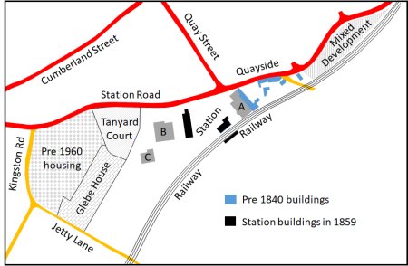
2020 map showing all the key features within the triangle
of land between Quayside, Station Road, Kinston Rd,
Jetty Lane and the railway.
After the last gas holder was demolished in 1976 a small industrial estate was created between the site of the former gas works, the road and the railway. The largest of the businesses was Rockford Marks who made wiring for a number of electrical and automotive companies. They moved to Eyke and, in 2003, the building became a showroom for a bedding company.
An application to build 14 flats on the site of the former gas works was rejected in 2003 and the owners soon demolished the boundary wall along Quayside and left the bricks scattered across the site. A revised application was subsequently submitted for a mix of 13 flats and 2 office units. Despite opposition from the Town Council and other local pressure groups the revised application was approved in June 2005.
The Deben Swimming Pool and the Community Centre are marked B and respectively C on the map above. They were both funded by Woodbridge Town Council. The Swimming Pool was built in 1976 and the Community Centre was completed some time later.
By 1985 Skinner’s Motor Body Repair Shop and Kay’s Engineering in the Tanyard were demolished and by 1990 they were replaced by Tanyard Court, a group of 36 retirement flats. Each flat was bought and sold independently but the management agent set an annual charge to cover ground rent and maintenance.
The long narrow building next to the station was a grain store. It ceased to be used in about 2000 and was then taken over by a refrigeration company. In 2004 there was a proposal for alterations to form offices, restaurant (with a balcony overlooking the river), five residential flats and warehouse, together with construction of a vehicular and pedestrian link between the station car park and the community centre car park. After a revision to change the scale to the proposed extension to the front of the building, and the size of the restaurant building at the rear, the proposal was accepted by the planning authorities. Work started towards the end of 2005.
In 2003 Woodbridge Town Council proposed to build a skateboard park at the rear of the Deben Swimming Pool on part of a site used as a coach park and recycling centre. Planning permission was given for this development but the discovery of high levels of methane gas in the area delayed work.
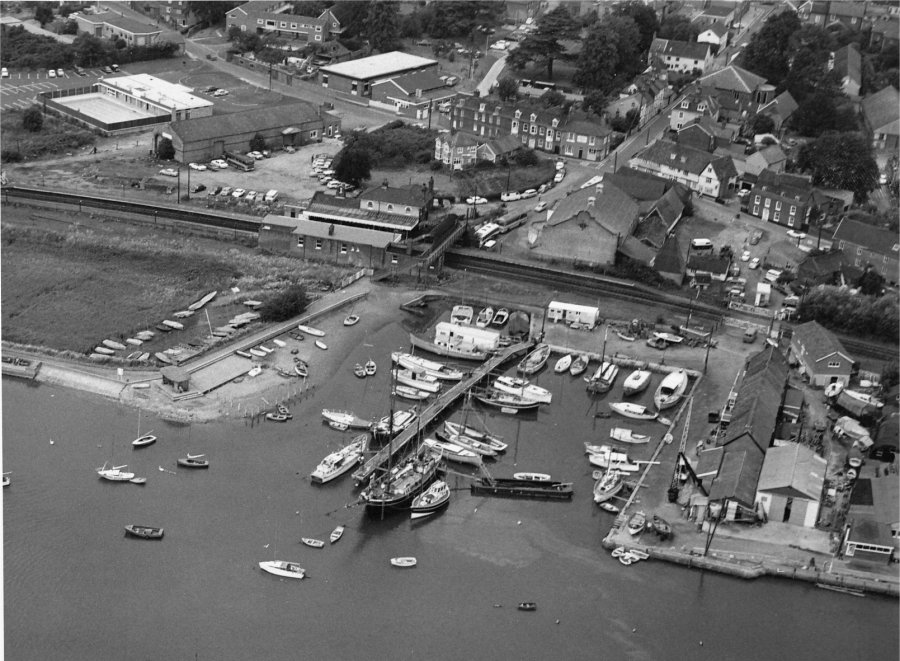
Some of these changes were underway when the two aerial photographs shown below were taken in 1973.
Phot313