Evolution of the Town and its Maritime Trade
The Royal Sites in South East Suffolk
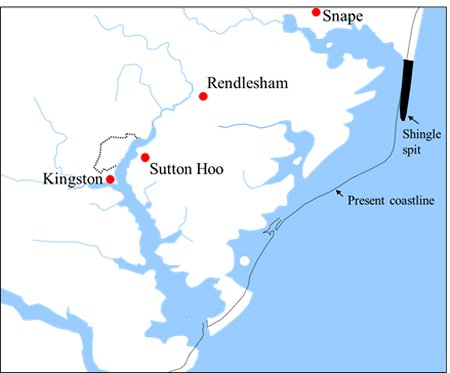
South-east Suffolk became the royal heartland of the Anglo-Saxon Kingdom of East Anglia. The longboat was the Anglo-Saxon’s primary form of transport and the Deben provided easy access into a good agricultural area. The location of the four royal sites in south east Suffolk are shown on this map.
The Wuffinga family provided the rulers of this kingdom until 749 and the ship burials at Sutton Hoo and Snape are believed to be the resting place of the early members of this family. Their Royal Hall was at Rendlesham. The promontory of Kingston was a royal manor where people came to pay their food rents to the king.
The locations of the four royal sites in
South East Suffolk. The
area was the royal heartland of the Kingdom of East Anglia.
The Royal Hall at Rendlesham
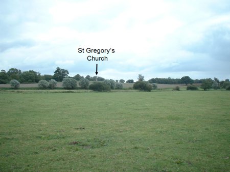
The flood plain of the River Deben at Rendlesham is in the foreground of the photograph to the right. Beyond it the land rises to a plateau by St Gregory's Church which is indicated by the black arrow. Ongoing archaeological investigations indicate that this plateau was an important place at the time of the ship burials at Sutton Hoo, and that the plateau was probably the site of the Royal Hall mentioned in Bede’s chronicle. From the plateau there is a wide view along the river valley towards Woodbridge and up the river valley towards Debenham.
When Anna became king of East Anglia in 636 he moved the Royal Hall from Rendlesham to Blythburgh, and the Deben valley ceased to be the royal heartland of the Kingdom of East Anglia.
Photograph of the plateau at Rendlesham which was probably
the site of the Royal Hall. It is just below St Gregory's Church.
The flood plane of the River Deben is in the foreground.
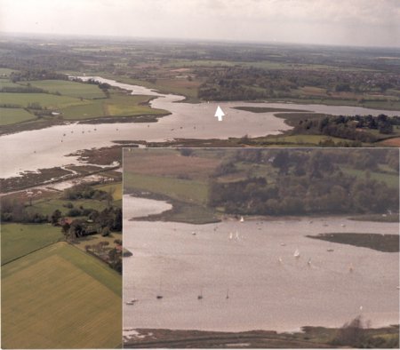
This photograph is an aerial view of a high promontory (now called Kyson Point) which was the Royal Manor of Kingston. The key feature of the promontory is a beach, marked by the white arrow, formed by the Deben cutting into the bank.
Because the rest of the upper estuary was lined by extensive salt marshes, the beach would have provided the ideal landing place for the longboats of those who came to pay their food rents to the king.
was
the Royal Manor of Kingston. The beach marked
by
the white arrow was the ideal landing place for longboats