Evolution of the Town and its Maritime Trade
The First Mention of Woodbridge
After the Danes invaded in 865 they settled in East Anglia and the northern areas of the Britain. Because they destroyed many charters and deeds, all written documents relating to Woodbridge are post the invasion. When the town was first mentioned in 959 it was called Uderdryge.
When Domesday Book was compiled in 1085 the town's name was written as either Uderbrige, Vdebryge, Vdebriga, Vdebriga, Wudebryge, Wudebrige and Wdebrige.

After the Danes invaded in 865 they settled here and destroyed the great body of East Anglian charters and deeds. All written documents relating to Woodbridge are thus post the invasion.
The most likely pronunciation of the name of the town is Wudebryge and this is Old Norse for wooden jetty or wooden bridge. The name Wooden Jetty would convey useful knowledge to people sailing up an estuary lined by extensive marshes, whereas any bridge would have been over one of the brooks that ran either side of the ridge on which the church stands, rather than across the much wider Deben estuary. As it is unlikely that such a bridge would be important enough to be conveyed in the name of the settlement, wooden jetty is probably the origin of the name of the town.

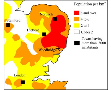
According to the population densities derived
from Domesday Book. Woodbridge was on the
edge of the most densely populated rural area.
Domesday Book reveals that Suffolk and Norfolk were the most populous shires in Britain by the time of the Norman Conquest.
This map shows how the population density varied across East Anglia. Woodbridge was at the edge of the most densely populated rural area within these counties. Woodbridge was, however, insignificant compared with Walton and Goseford which were at the entrance to the Deben estuary.
According to the population densities derived from Domesday Book Woodbridge was on the edge of the
most densely populated rural area in the country.
Goseford - An Important Maritime Centre at the Entrance of the Deben Estuary
The location of Goseford is shown by this map. Goseford was just an area of the Deben estuary where there were a number of landing areas and secure anchorages. It was a thriving maritime centre by the time of the Norman Conquest and there was a market at nearby Walton.
Walton Castle, near the entrance to the Deben estuary, was one of the homes of the Bigod family who, by the twelfth century were Earls of Norfolk. After the castle at Walton had fallen to Edward I, Goseford became recognized as a base for assembling foreign expeditions.
Other landing places along the estuary, such as that at Woodbridge, were just appendages of Walton.
Goseford and Walton eventually faded away because Woodbridge served a much larger and more diverse hinterland.
Map showing the location and extent of Goseford.
