Evolution of the Town and its Maritime Trade
In 1536 Woodbridge Priory was dissolved and both the priory building and the nearby Anglo-Saxon church were soon demolished.
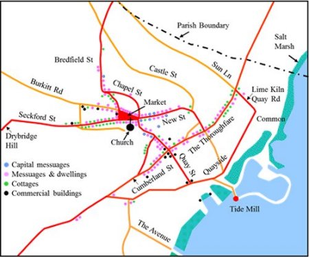
A document called an Extent was produced, in 1560, to detail the holdings of the manor of Woodbridge late Priory, and from it the map to the right is derived. All the roads shown still exist today although most of their names have changed. The modern names are used here to avoid confusion.
The houses which lined the streets were described (in order of grandeur) as capital messuages, messuages, dwellings and cottages.
Map of the town based on the information given in the 1560 Extent. The road names are those used today.
Some of the houses in Woodbridge would not have been listed in the Extent because they were on land belonging to another manor. When allowance is made for this, it is estimated that there were 215 houses in the town in 1560. All of them would have been timber framed.
There are still 153 timber such houses in the town today but most of them, like the one of right of this picture, have an early 1800s brick facade. The timber framed house on the left is still in its original state.
On the left of this photograph there is a timber frame house which is still in its original form. On the right there is a timber framed house which has had a brick facade added.

From the Extent it is clear that, in 1560, the riverside was lined by extensive marshes. The river walls were not built until the early seventeenth century.
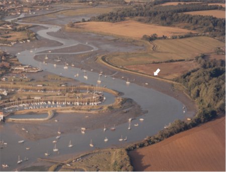
Part of the river wall on the far side of the estuary is marked by a white arrow on the aerial photograph to the right. The photograph shows the stretch of the Deben from the quays by the Tide Mill to the bridge at Melton. The river wall enabled the low lying land to the right to reclaimed. The mud and saltings to the left of the wall are covered at high tide.
The river walls also confined the river and thereby eventually deepened it. This had a significant impact on maritime trade.
The river wall (arrowed) on the far side of the estuary can be clearly seen on this aerial view of the Deben from the tide mill yacht harbour to the bridge at Melton. The building of the river wall enabled the low lying land to the right of it to be reclaimed. The mud and saltings to the left are covered by water at high tide.