Key places along the Deben Estuary
Wilford Bridge was built in 1530. Prior to this it was only possible to cross the river at low tide by using stepping stones. In 1764 the bridge was demolished and replaced by a brick structure. It soon became apparent that there were problems with the structure so the bridge was rebuilt with white brick. In 1939 the old bridge was declared unsafe and the road was closed whilst a new one was built at a different angle. Melton quay was established near the bridge in 1840 to receive stone for the roads.
Ferry Cliffs were above the landing place for the Woodbridge ferry. This ferry served the Sandling villages long before Wilford bridge was built. The bridge did not remove the need for the ferry because it was still quicker for many of those walking to Woodbridge Market. The ferry ran from the Quay at the Tide Mill to near Sutton Cliff until the present river wall and landing place were made in 1874. The ferry originally belonged to Manor of Stockerland-in-Sutton, and the first recorded ferryman was John Beal who in 1509 paid an annual rent of 6s 8d. As Woodbridge increased in importance, the Lord of the Manor of Woodbridge-late-Priory acquired some control over the ferry, presumably because the Ferry Quay was manor property.
Victorian families used the Woodbridge Ferry to reach the picnic area on the Sutton Cliffs. In the late Victorian era the ferry was a vital link in preserving the respectability of Woodbridge residents. The male population were allowed to swim on the Sutton side of the river where a sandy beach then existed below the Sutton Ferry Cliff. The ladies swam behind the Tide Mill where there was a caravan in which they could change into their bathing costumes.
The rights of the ferry were given to Woodbridge Urban District Council in 1919 and the demand for the ferry was such that, right up to Second World War, the ferryman paid for the privilege to operate it. After the war it became a service supported by a grant from the Council but few people used it. In 1950 the Urban District Council announced that they were going to stop the ferry because so few people wanted to use it but they were prevented from doing so by a High Court Action. The ferry continued until 1974 when the new Suffolk Coastal District Council stopped paying for it.
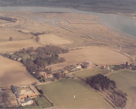
Tempe Common is at the top of the ridge running down to Kyson Point. The Woodbridge pilots kept watch from Tempe Common because from there they could look down river. When a ship was sighted, a pilot would walk along a path skirting Tempe Wood to his lug-sail boat moored at Kyson point. From there he would sail down river to the Bowship Beacon.
Kyson Point is part of the Royal Manor of Kyson. When the Anglo-Saxons used the Deben estuary most of it was lined by extensive salt marshes and the beach on the Woodbridge side of the Kyson point was probably the highest point up the estuary where longboat could land and thus became the place where people came to pay their food rents to the king.
In 1622 Thomas Warner of Parham sailed from the shores of Kyson to St Kitts in the Leeward Islands to grow tobacco. This voyage was the start of Britain’s West Indian expansion. In the eighteenth century some of the loaded schooners bound for Lime Kiln Quay ships had to be lightened by having some of their cargo taken off at Kyson by smaller boats (lighters). By 1844 all the buildings on Kyson point were associated with a brickyard run by William Colchester and Co.
Martlesham Creek, which leads to the River Finn, is now only navigable for a short distance but once possible to go further, maybe as far as Burg near Grundisburgh. The Roman villa there may have been a country house of the Counts of the Saxon Shore who had their fortress at Walton and could have ascended to Burg on the tide. Crossing the Finn was the sede-ford or seckfod, which is the derivation of the name Seckford -Woodbridge’s Tudor benefactor. This ford was superseded by the Mediaeval bridge. Martlesham Church, like many others along the Deben, was built by a creek so that building material might be brought to it via the water.
Suez Beacon and Lower Troublesome Beacon mark the twist in the channel opposite Martlesham Creek and the entrance to that section of the river known as Troublesome Reach. It has been so called for untold years owing to the fluky winds that come down from the creek making it a particularly troublesome reach to beat up. Suez Beacon stands at the entrance to a channel called Loder's Cut which was dug through the mud in 1879; a few years after the great Egyptian water way was opened.
Horse Beacon marks the place where a ships voyage from Woodbridge was deemed to begin. Thus arose the custom of ‘wetting' the horse by breaking a bottle to wish good luck to the voyage. It also marked the end of a voyage. Fires were lit when the beacon was passed and. food put on the stove to cook. If the ship were becalmed hereabouts, the crew were allowed to go home.
Methersgate Quay was probably a manorial landing-place of the Manor of Campsey. From the quay there is an old track way across the heath to Ufford, Staverton and Butley. By 1844 there was a brickworks near by.
The Hams and the Tips These sandy tips were built out into the river during the latter part of the 19th century by Robert Cobbald, a Sutton farmer, in an endeavour to reclaim 150 acres of land. He was eventually stopped by Trinity House who feared that the tips would alter the course of the river and hence interfere with navigation.
Stonner Point was once a manorial landing place. Around 1850 Stonner Quay was established for the shipping of Coprolite. These phosphate nodules formed in the layers of excreta and bones on the bed of the sea which covered this area. Thousands of tons of this ‘dung stone’ were shipped annually from Deben side Quays to all parts of the kingdom. The trade died out in about 1895 with the advent of new kinds of fertilisers.
Waldringfield In 1876 a factory was established at Waldringfield to make Portland Cement from common chalk and river mud (ooze). When the factory was in full swing it had 7 kilns and a fleet of 7 sailing barges trading between the Waldringfield Cement Works and the Thames. At times as much as 400 tons a day was loaded. The factory was supplied with mud by the barge Kingfisher. Two men used to take her down river to just below Waldringfield and, in one tide, load her by hand with 25 tons of mud from the saltings. The cement works was owned by “Masons Portland Cement” who also had a much larger complex at St Peter’s Timber Yard in Ipswich.
The Rocks This reach of the river takes its name from the hard rocky bottom made up of Septaria. These limestone nodules are a form of fossilised jellyfish and there are also large deposits at the foot of Felixstowe cliffs. This stone, called "Rockstone", has been used for building. Orford Castle was made from it and Cardinal Wolsey used it for his College at Ipswich. In the nineteenth century demand for the stone much increased because it was used in the manufacture of cement
Kirton Creek There was a ferry from Kirton Creek to the other side of the river. The field above where it used to land was known as Ferry Hemp-land. Most Suffolk villages had their hemp-lands. They originated from the time of Queen Elizabeth when anyone who farmed more than 60 acres was obliged by law to grow a crop of flax or hemp.
There were salt pans on the extensive salt marshes that ran from Kirton Creek to Waldringfield. The salt collected in these pans was sent to Woodbridge for refining.
Ramsholt Church commands a fine view of the entrance to the Deben. There are 41 such towers in Suffolk and it is believed that they are of the period of the Danish Invasions and that they were built for defence. Ramsholt church tower could have been a look out post to provide warning of Viking raids.
Kingsfleet is now a large drainage ditch but in Norman times, before the river wall was built, the area was an expanse of sheltered water behind the high ground of Walton and Walton Castle. This area of sheltered area water was a natural harbour of the port of Goseford. The castle was one of the homes of the Bigod family who, by the twelfth century, were Earls of Norfolk. After the castle had fallen to Edward I, it was replaced by a royal manor and Goseford became recognized as a base for assembling ships for foreign expeditions. In Suffolk fleet means shallow, so Kingsfleet was simply the shallow creek used by the Kings. Alternatively the name might just reflect the fact the area was one used by kings to assemble their fleets.
Bawdsey Manor overlooks the entrance to the Deben. It was finished in about 1886 having taken some 18 years to build. It was the hub of Sir Cuthbert Quilter’s 8000 acre estate which extended almost to Woodbridge. He was a stockbroker, financier and politician. In 1936 the manor was used as a top secret research establishment and it was here that the radar system, which played a pivotal roll in the Battle of Britain, was developed. The Manor remained an RAF station until 1991.
The Bar The shingle banks which line the entrance of the Deben change their shape and direction every year but, if old charts are to be relied upon the depth of water over the bar between them has hardly changed over the last 400 years.
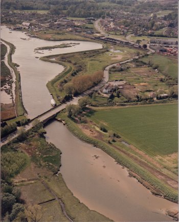
Wilford Bridge
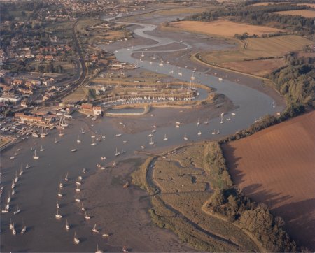
Above Woodbridge Pool looking up to Wilford Bridge
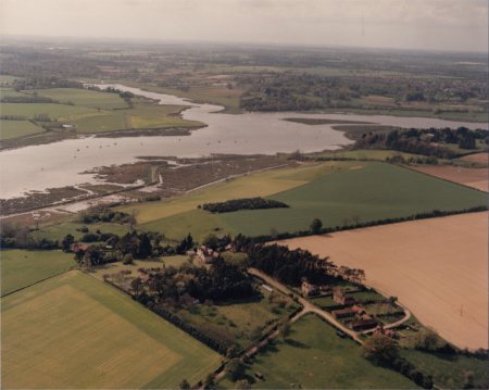
Looking towards Kyson Point. Martlesham Creek goes off to the left and the entrance to Woodbridge pool is on the right.
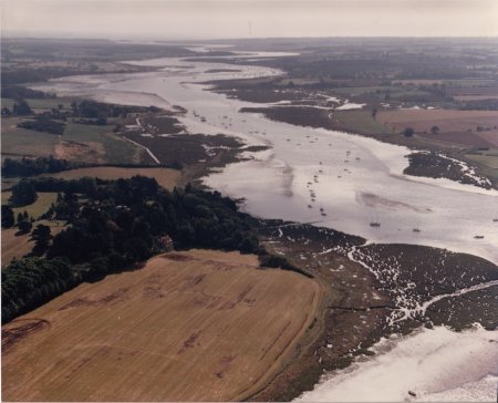
Looking down river from above the bank opposite Kyson Point.
Looking up river from above Hemley
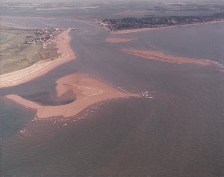
The shingle banks which line the entrance to the Deben estuary.