Other Sources of Employment and the Growth of the Town
Employment Opportunities Post 1960
By 1950, despite the creation of a range of new employment opportunities in the manufacturing sector, nearly half of the working population of Woodbridge was employed in agriculture and forestry in the rural areas outside the town and in the market gardens and nurseries in the town. Manufacturing industries in Woodbridge and district only supported 8.7% of the workforce. Most of the remainder were employed in the service industries many of which operated in Woodbridge or nearby locations. Both the Woodbridge Urban District Council and the Deben Rural District Council had their headquarters in Woodbridge and nearby there were the Headquarters of the East Suffolk Agricultural Executive, the Borstal at Hollesley, a large mental Hospital at Melton and the airfields of the RAF and USAF.
During the 1960's employment opportunities within the town were decreasing again. Many of the smaller manufacturing companies had either closed or left the town. The market gardens in Woodbridge had closed as had the farms at Drybridge Hill and Kingston which were part of Suffolk Seeds. The loss of employment, however, did not affect the town as much as it would have done in previous years. The rise in car ownership made it possible for people to live in Woodbridge and yet work some distance away.
When several large London companies relocated from London to the Ipswich area in the early 1970's many of their employees decided that Woodbridge and Melton were the perfect place to live and the populations of both communities increased significantly. The location of the new houses needed to accommodate the new arrivals was set out a Town Plan which was finalized in 1967.
The Town Plan enlarged considerably the amount of land which could be used for residential development in Woodbridge and Melton. It also split this land into eight zones, shown on the map to the left. For each zone there was a specified housing density.
The light blue area near the centre of the map used for Farlingay High School and the Seckford Grammar School. Most of remaining light blue areas were mainly for public open spaces, a nursery and cemeteries.
The black area in the centre of the Woodbridge was designated as a commercial area.
The royal blue areas on the map were designated as an industrial areas.
In 1969 a separate document designated the central core of Woodbridge as a Conservation Area. This document and its subsequent revisions has ensured that all the buildings of special architectural or historic interest are protected by statutory controls.
The planning zones defined by
the 1967 Town Plan.

By 2015 nearly all of the building development envisaged in the town plan had been implemented and the town was shown by the map to the left. The areas shaded grey were developed by 1958 whilst those which are purple were developed from 1958 to 2015. Clearly most of the areas designated for development in the 1967 Town Plan had been built upon.
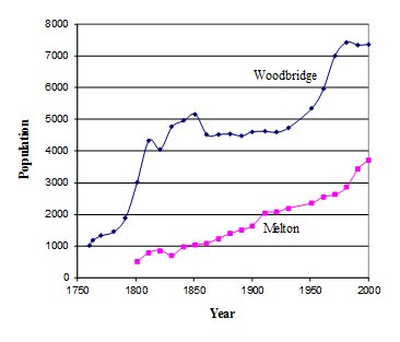
The amount of land in Woodbridge which was suitable for house building was constrained by the A12 and the estuary. When this land was used up, house building started in the adjoining parish of Melton and its population began to rise as shown by the graph below.
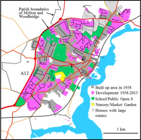
Woodbridge in 2015. The areas developed between 1958 and 2015 are shaded purple