The Public Houses in Woodbridge
In sixteenth century documents there are references to a brewery in Woodbridge and to meetings in buildings which are believed to be inns or taverns. It is not until the early nineteenth century, however, that it is possible to produce a comprehensive list of the inns, taverns and beer houses in the town.
In 1828 Isaac Johnson produced a map of the town showing the locations of twenty-one inns or taverns, and the tithe apportionment of 1838 lists twenty-two inns or taverns and one beer house. Thereafter the only listings of inns, taverns and beer houses are to be found in trade directories. These lists have two limitations. Firstly, none of the early directories distinguish between inns and taverns. Secondly, although some directories clearly identify beer houses, others treat them as inns or taverns. Because of these two limitations, it is only possible to use directories to obtain the total number of inns, taverns and beer houses in the town. Today such establishments are collectively referred to as public houses.
Using the various sources mentioned above it is possible to show how the number of public houses in Woodbridge has changed since 1838 and the results are presented in the table on the right. The number of public houses rose from 23 in 1838 to a peak of 37 in 1874 and then declined to 20 by 1937. By 2015 there had been a further reduction to 9. All but 3 of the post 1937 closures occurred between 1950 and 1972.
The changes in number of inns, taverns and beer houses in Woodbridge over the period 1838 to 2015
| Source | Number of inns, taverns and beer houses |
| 1838 Tithe Apportionment | 21 |
| White's 1844 Directory | 23 |
| Melville's 1865 Directory | 35 |
| Whites 1874 Directory | 37 |
| Kelly's 1888 Directory | 33 |
| Kelly's 1927 Directory | 21 |
| Survey in 2015 | 9 |
Of all the public houses which remain in the town, the Mariner's Arms is the only one which is not at least 300 years old. The Angel, the King's Head, the Bell and Steelyard and the Crown are all believed to date back to the 16th century. The Bull and the Crown have the distinction of being coaching inns which had extensive stabling.
The locations of the public houses are shown by the map on the right. The pink circles mark the locations of those which were recorded in 1844 and were still open in 2015. The black circles, triangles and squares mark the locations of public houses which had closed by 2015. Black circles are used for those which were recorded in 1844, black triangles for those which opened some time later and black squares for those whose location can only be narrowed down to a particular street rather than a building.
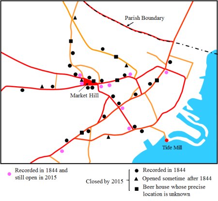
Map showing the locations of all public houses in Woodbridge which were open at some time during the period 1844 to 2015.